A Civic Legibility Audit · Columbia County, NYVol. I · Kinderhook Node · Pilot Edition
The Kinderhook Field Report
How findable Kinderhook is to the channels its commerce depends on.
Conducted by Harmonic Systems · A civic-vitality and machine-legibility report on Kinderhook, NY
Editor's Note
Kinderhook holds an unusual amount for a village of its size: a Manhattan gallery's upstate space at the Knitting Mill, the Aviary's cathedral-ceilinged dining room, the Old Dutch Inn on Broad Street, the Saturday farmers' market from May through October, the Van Buren grave a short walk from the village green. Generations of work — by residents, the village government, the county tourism board, the businesses themselves, and the volunteer organizations that hold so much of it together — have built and maintained this. The cultural and commercial ground is real.
The geography around it is favorable. Two and a half hours from New York City, twenty-five minutes from Albany, a fifteen-minute drive from Amtrak service that puts Manhattan inside two hours by rail. Kinderhook sits inside the weekend reach of seventeen million people, just upstream of the Hudson Valley wave that has already reshaped Hudson, Rhinebeck, and Beacon. NYC visitors are looking for villages exactly like this one.
Increasingly, those visitors plan trips by asking phones, search engines, and AI assistants "where should we go for a weekend in the Hudson Valley?" Those channels can recommend what they can structurally read. This report reads what those channels currently see when they look for Kinderhook — across the county tourism site, the village's own pages, state and federal records, and the broader commons — and proposes the publishing patterns that would let the village's existing assets show up where today's visitors are looking. The work the village has already done is the foundation; this report is about what to add on top of it.
A Finding
Reading…
Part One
Who's coming through
§ I · Demographics
Who the Census says we are
api.census.gov · acs/acs5
American Community Survey 5-Year estimates for two geographies: the incorporated Village of Kinderhook (place 36-39562) and the surrounding Town of Kinderhook (county subdivision 36-021-39573). The two are not the same place; the difference is most of the local story.
Loading snapshot…
§ II · Transportation
The roads that carry the village
data.ny.gov · 6amx-2pbv · wpyb-cjy8
NYSDOT publishes Annual Average Daily Traffic counts for every roadway segment under state inventory, and condition data for every state-owned bridge. Below: how many vehicles pass through Kinderhook on a given day, and the structures that carry them across the village's creeks.
Loading snapshot…
Part Two
What's here
§ III · CCT Businesses
Everywhere CCT points in the village
/business/{slug}/ × 594
The biggest single drill-down: the county's full business directory, fetched page-by-page at build time from the Yoast sitemap, then filtered to our village by address. This is what CCT tells the world about Kinderhook when it lists businesses.
Loading snapshot…
§ IV · Open Hours
When the village is actually open
schema/hours/manifest.json
Neither CCT nor the village directory publishes machine-readable opening hours for any business in Kinderhook. The corpus below is hand-curated, in the editorial pattern of schema/places/: weekly hours per business, expressed as schema.org openingHoursSpecification. A reader (human or machine) can answer "what's open at 4 p.m. on a Sunday in April" without scraping a single page.
Loading corpus…
§ V · Curated Places
What we have written
schema/places/*.json
The hand-kept corpus. Each entry is a JSON file under schema/places/, edited as a file, versioned in public, and loaded by this page at read-time. The county's data plus the commons' data plus these make a legible village.
Loading corpus…
§ VI · Farmers Markets
What the state knows about the market
data.ny.gov · qq4h-8p86
The NYS Department of Agriculture and Markets keeps the authoritative public record of every farmers' market in the state — operating season, weekly hours, SNAP/EBT acceptance, contact. The Kinderhook Farmers' Market we curated by hand at schema/places/ appears here too. The state is a primary source we cite; the curated entry is the editorial overlay.
Loading snapshot…
Part Three
What pulls people in
§ VII · Historic Layer
Kinderhook as deep time already knows it
wikidata · wikipedia · loc
Before the URL slug, the village. Structured historical knowledge the commons has already written down, snapshotted at build time: NRHP listings, notable residents, Wikipedia summaries of the canonical sites, and two centuries of newspaper mentions.
Loading snapshots…
§ VIIb · Historic Districts
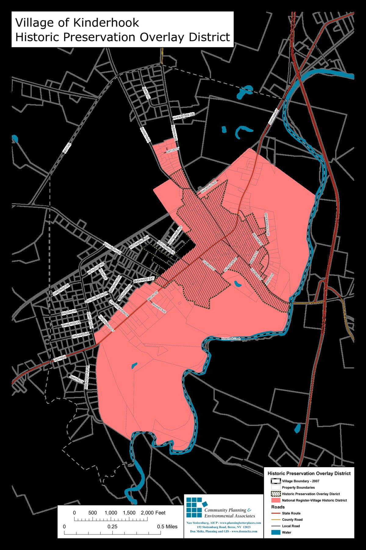
Two maps say historic. Only one is in force.
ecode360 ch 75 · ch 130 · cpea 2008
A house in the village can be on the National Register and free to renovate. Another, two streets away, can be off the federal register and still need permission to repaint its trim. The village code distinguishes the two; residents commonly conflate them. The map below is the clearest published depiction we have of both boundaries on the same sheet.
Two boundaries govern what the word historic means inside the Village of Kinderhook, and they are not the same shape.
The smaller of the two is the Historic Preservation Overlay District, established by Village Code Chapter 75 and depicted on the Zoning Map (Chapter 130, Attachment 4). It covers the historic commercial and residential core: Broad, Hudson, the Albany Avenue spine, Maiden, Church, Silvester, the Rothermel area. Properties inside this overlay need a certificate of appropriateness from the village's Historic Preservation Commission before they can alter exterior features, build additions, or demolish. This is the regulatory boundary — it is the one a property owner has to know.
The larger is the Kinderhook Village Historic District on the National Register of Historic Places (NRHP listing #74001225). It extends south to Kinderhook Creek, covers the southern village agricultural lands, and reaches further north along Albany Avenue. Federal listing only. It confers eligibility for federal historic-preservation tax credits and triggers federal Section 106 review when federal funding or permits are in play. It has no effect on what a property owner can do to a private exterior on their own dime.
The two boundaries overlap but do not match. A property in the pink (NRHP) zone but outside the hatched (overlay) zone is "historic" in the federal sense but free of any village review. A property in both zones is subject to the village's certificate-of-appropriateness process. A property in neither — perhaps an older home on a quieter outer block — is governed only by general zoning.
The conflation matters because it cuts both ways. Some residents believe their property is regulated when it is not, and ask permission they don't need. Others believe their property is unregulated when it is not, and find out otherwise mid-project. Both surprises are avoidable from the same map.
Village of Kinderhook — Historic Preservation Overlay District, 2008Hatched: local Historic Preservation Overlay (regulated). Pink fill: National Register district (federal listing only). Prepared by Community Planning & Environmental Associates (Nan Stolzenburg, AICP) with GIS by Don Meltz, October 2008. Source PDF.
What journalists outside the establishment have written
schema/coverage/*.json
Hand-curated. Independent reporting on Kinderhook from publications outside the tourism board's orbit. Each entry is a citation, not a republication — readers click through to the original; the publishers get the traffic. The list grows by editorial decision, not by scrape.
Loading corpus…
§ IX · Editorial Record
What the county has said about us
/wp/v2/posts?categories=…
Articles tagged with this village by the tourism board's editors. A decade of travel writing, already categorized by place — an under-used affective layer.
Fetching posts…
Part Four
What it costs to operate here
§ X · Assessments
What every parcel is worth on the books
data.ny.gov · 7vem-aaz7 · bsmp-6um6
NY ORPTS publishes the annual assessment roll for every municipality. Read here for the village (SWIS 104401) and the surrounding town outside the village (104489): parcel count, total assessed value, total full-market value, and the dominant property classes. The Residential Assessment Ratio time series — the state's official assessed-to-market ratio — drives the calculator below.
Loading snapshot…
Assessment Calculator
Enter a market price; see what the state's ratio would call its assessment.
RAR is the state's official ratio between assessed value and full market value for residential property, derived from a sample of arm's-length sales each rate year. The result is the typical assessment for a property at this market value — individual parcels deviate; the variation band above is the state's coefficient of dispersion. Residential only; not applicable to commercial or vacant-land parcels.
§ XI · Market Movement
How the state measures the village's market
data.ny.gov · 4sut-q3dt
The state does not publish parcel-level sales records as machine-readable data — only county-level PDFs. What it does publish, annually, is what the sales imply: a residential market-value ratio, a coefficient of dispersion, and a price-related differential, computed from arm's-length sales in the Town of Kinderhook. The series below is the only legible signal of the local residential market in two decades.
Loading snapshot…
§ XII · Climate Smart
What the village has pledged
data.ny.gov · 2c5p-4m2k
The Climate Smart Communities program, run by the NYS Department of Environmental Conservation, is a statewide ladder: jurisdictions take a pledge across ten policy categories, then earn points for documented actions to escalate from Registered → Bronze → Silver → Gold. Below: the village's certification status, the Columbia County peers it sits among, and the statewide context.
Every federal disaster declaration that designated Columbia County, NY (FIPS 36-021), since 1965. One row per declaration. This is the legible record of what the federal government has said happened to this place — flood, fire, ice, pandemic — and which programs were authorized in response.
Loading snapshot…
Part Five
Whether anyone can find you
§ XIV · CCT Footprint
Everything the county machine-readably knows
/wp/v2/search?search=kinderhook
Columbia County Tourism's full published index of Kinderhook, across every content type it exposes to search. This is the overview; the next four sections drill into each type in turn.
Querying…
§ XV · Ontology
How the county categorizes itself
/wp/v2/{taxonomy}
Before writing our own schema we read theirs. CCT publishes four taxonomies via REST. Each card below shows the full term list, county-wide, with any Kinderhook entries highlighted in cinnabar. The Kinderhook match count is what every later section filters against — if a taxonomy has zero Kinderhook terms, the village is invisible to that surface of the site.
Fetching taxonomies…
§ XVI · Events
What happens in the village
/tribe/events/v1/events
Upcoming events at Kinderhook venues, read live from The Events Calendar. Each appears below as it would if a machine were asking the county what is scheduled here.
Fetching events…
§ XVII · Event Venues
Places that host things
/tribe/events/v1/venues
A precise, narrow category: places in Kinderhook the county's event system currently recognizes as hosting events. Not the same as "places in Kinderhook" or even "businesses that could host an event" — a venue only appears here if something is scheduled in it.
Fetching event venues…
§ XVIII · Cross-references
What the wider commons already knows
wikidata · overpass
Before we write new identifiers, we look for existing ones. Wikidata carries structured civic knowledge; OpenStreetMap carries the ground truth of named places. Both are authorities we can link to with sameAs.
Wikidata
query.wikidata.org/sparql
Querying…
OpenStreetMap
overpass-api.de
Querying…
§ XIX · Diagnostic
What the machines cannot see
(derived)
The county's data model has shape. This is what we found missing from the public surface — the specific gaps that make Kinderhook less legible than it could be.
Part Six
What would change this
§ XX · Proposed Schema
What we would publish instead
schema.org · JSON-LD
Given what's already there, and the village-local judgement we add, here is the JSON-LD that would make the Kinderhook Farmers' Market correctly addressable by language models, assistants, and the next generation of discovery tools.
The same graph is also published as a single addressable file: kinderhook.json. Fetch that if you want this report's structured data in one piece.
Awaiting data…
Every item above could carry one of these blocks. The taxonomy is the county's; the disambiguation and local judgement is ours. The machines stop guessing.
What We Ask
Five concrete things that, if implemented by the parties named, would close the largest legibility gaps in this report.